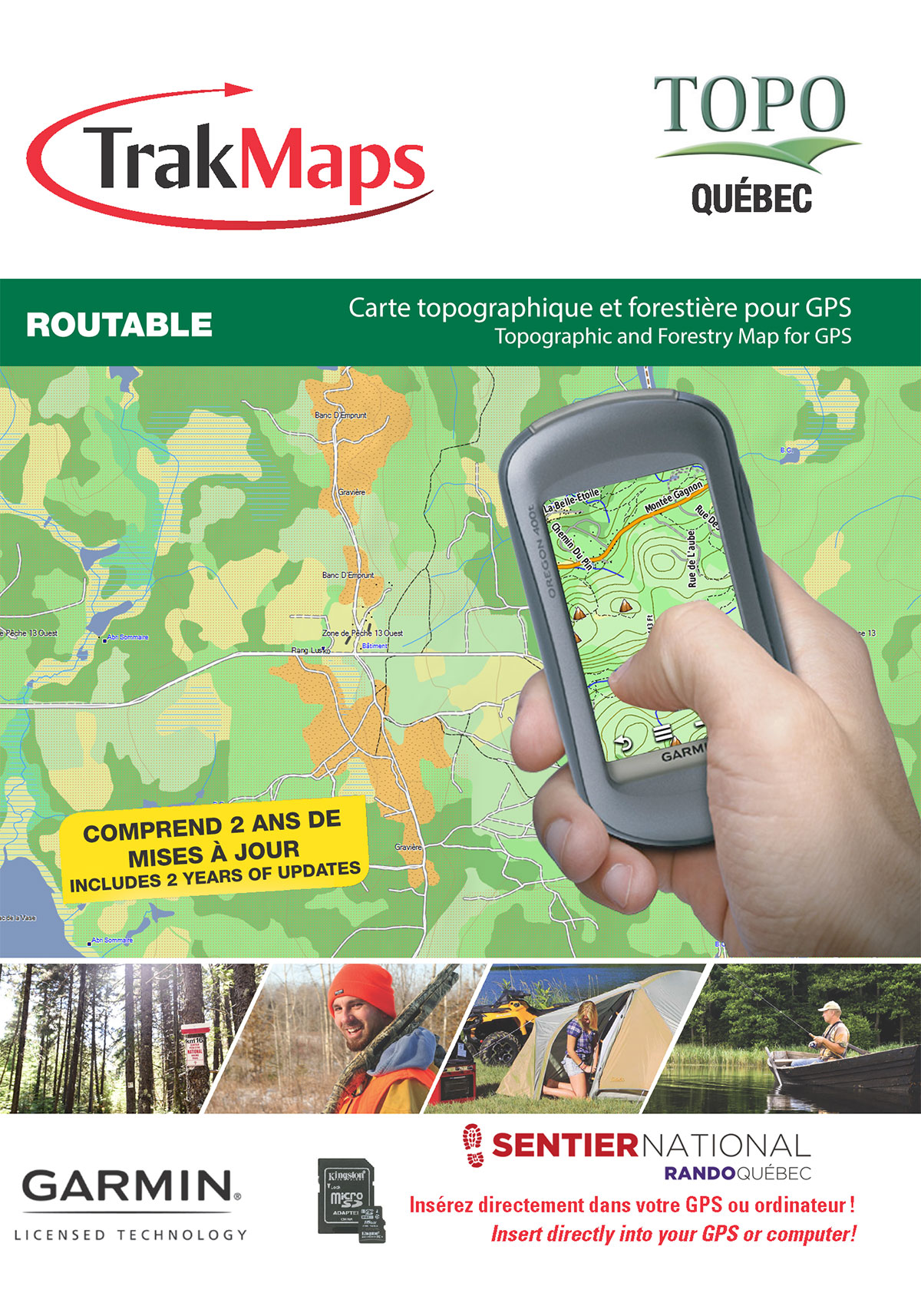
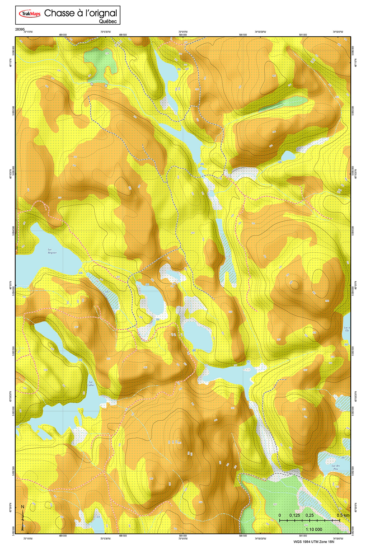
Carte imperméable de Davidson Inlet and Sea Otter Sound;Edna Bay | Carte NOAA 17403 | TrakMaps

Davidson Inlet and Sea Otter Sound;Edna Bay | Carte NOAA 17403


Inclus

  • Bathymétrie
  • Aides à la navigation
  • Entraves à la navigation
  • Imprimé sur papier imperméable et indéchirable

COMMANDEZ-LA AUJOURD'HUI

34,50 $

Description

Davidson Inlet and Sea Otter Sound;Edna Bay | Carte NOAA 17403. Impression sur papier imperméable et indéchirable. Idéale pour plaisance et pêche.

Carte plus supportée


Sources

  • Service hydrographique du Canada
  • Ministère de l'Énergie et des ressources naturelles du Québec
  • National Oceanic and Atmospheric Administration
  • Ressources naturelles Canada
  • Ministère des Richesses naturelles et des Forêts de l'Ontario
  • National Geospatial-Intelligence Agency
  • TrakMaps

Ce produit ne contient pas les données de toutes les sources affichées ci-haut. Autres sources pourraient être utilisées également.

Spécifications

FormatCarte du NOAA
PrésentationRoulée
Légendes
PapierImperméable et indéchirable
Dimensions41" x 34"
Pages1
Échelle1/40 000
* Veuillez noter que ces dimensions sont estimées ou arrondies. Pour obtenir les dimensions précises, veuillez nous joindre.

Exemples

Images ci-haut sont réservés à des fins de démonstration.

Couverture

Le rectangle rouge dans la carte ci-dessus sert uniquement à indiquer l'étendue du produit. Il ne représente pas le contenu du produit.

Trouvez d'autres cartes du NOAA


Je m'en vais à

213
132
32
14
7
43
29
2
2
2
15
4
12
39
30
270
414
398
3
8
4
5
9
6
69
51
59
3
8
14
51
5
5
5
8
8
3
9
20
18
Carte
Prix
Carte
Prix
Adak Island to Tanaga Island | Carte NOAA 1646734,50 $
Agattu Island | Carte NOAA 1643434,50 $
Akutan Bay, Krenitzin Islands | Carte NOAA 1653234,50 $
Alaska - West Coast. Delong Mountain Terminal | Carte NOAA 1614534,50 $
Alaska Peninsula and Aleutian Islands to Seguam Pass | Carte NOAA 1601134,50 $
Albion to Caspar | Carte NOAA 1862834,50 $
Aleutian Islands Amukta Island to Attu Island | Carte NOAA 1601234,50 $
Algoma to Sheboygan;Kewaunee;Two Rivers | Carte NOAA 1490334,50 $
Alitak Bay-Cape Alitak to Moser Bay | Carte NOAA 1659134,50 $
Altamaha Sound | Carte NOAA 1150834,50 $
Amchitka Island and Approaches | Carte NOAA 1645034,50 $
Amelia Island to St. Augustine | Carte NOAA 1148834,50 $
Amkta Island to Igitkin Island;Finch Cove Seguam Island;Sviechnikof Harbor, Amilia Island | Carte NOAA 1648034,50 $
Anacapa Passage;Prisoners Harbor | Carte NOAA 1872934,50 $
Anacortes to Skagit Bay | Carte NOAA 1842734,50 $
Anclote Keys to Crystal River | Carte NOAA 1140934,50 $
Andrenof. Islands Tanga Bay and approaches | Carte NOAA 1646234,50 $
Annapolis Harbor | Carte NOAA 1228334,50 $
Apalachee Bay | Carte NOAA 1140534,50 $
Apalachicola Bay to Cape San Blas | Carte NOAA 1140134,50 $
Approaches to Admiralty Inlet Dungeness to Oak Bay | Carte NOAA 1847134,50 $
Approaches to Blue Hill Bay | Carte NOAA 1331334,50 $
Approaches to Cape Fear River | Carte NOAA 1153634,50 $
Approaches to Chesapeake Bay | Carte NOAA 1220834,50 $
Approaches to Everett | Carte NOAA 1844334,50 $
Approaches to Galveston Bay | Carte NOAA 1132344,50 $
Approaches to Lahaina, Island of Maui | Carte NOAA 1934834,50 $
Approaches to Mississippi River | Carte NOAA 1136634,50 $
Approaches to New London Harbor | Carte NOAA 1321234,50 $
Approaches to New York Fire lsland Light to Sea Girt | Carte NOAA 1232634,50 $
Approaches to New York, Nantucket Shoals to Five Fathom Bank | Carte NOAA 1230034,50 $
Approaches to Niagara River and Welland Canal | Carte NOAA 1482234,50 $
Approaches to Penobscot Bay | Carte NOAA 1330334,50 $
Approaches to Port Canaveral | Carte NOAA 1148134,50 $
Approaches to San Diego Bay | Carte NOAA 1877234,50 $
Approaches to San Diego Bay;Mission Bay | Carte NOAA 1876534,50 $
Approaches to San Juan Harbor | Carte NOAA 2566934,50 $
Approaches to St. Johns River;St. Johns River Entrance | Carte NOAA 1149034,50 $
Approaches to Strait of Juan de Fuca Destruction lsland to Amphitrite Point | Carte NOAA 1848034,50 $
Approaches to Yaquina Bay;Depoe Bay | Carte NOAA 1856134,50 $
Aransas Pass to Baffin Bay | Carte NOAA 1130734,50 $
Arctic Coast | Carte NOAA 1600334,50 $
Ashland and Washburn harbors | Carte NOAA 1497434,50 $
Ashtabula Harbor | Carte NOAA 1483634,50 $
Ashtabula to Chagrin River;Mentor Harbor;Chagrin River | Carte NOAA 1482534,50 $
Atka Island to Chugul Island Atka Island | Carte NOAA 1648434,50 $
Atka Island, western part | Carte NOAA 1648634,50 $
Atka Pass to Adak Strait;Three Arm Bay, Adak Island;Kanaga Bay, Kanaga Island;Chapel Roads and Chapel Cove, Adak Island | Carte NOAA 1647134,50 $
Attu Island Theodore Pt. to Cape Wrangell | Carte NOAA 1643034,50 $
Bahia de Boqueron | Carte NOAA 2567534,50 $
Bahia de Fajardo and Approaches | Carte NOAA 2566734,50 $
Bahia de Guanica | Carte NOAA 2567934,50 $
Bahia de Guayanilla and Bahia de Tallaboa | Carte NOAA 2568134,50 $
Bahia de Jobos and Bahia de Rincon | Carte NOAA 2568734,50 $
Bahia de Mayaguez and approaches | Carte NOAA 2567334,50 $
Bahia de Ponce and Approaches | Carte NOAA 2568334,50 $
Bahia de San Juan | Carte NOAA 2567034,50 $
Baker, Noyes, and LuluIslands and adjacent waters | Carte NOAA 1740634,50 $
Baltimore Harbor | Carte NOAA 1228134,50 $
Baptiste Collette Bayou to Mississippi River Gulf Outlet;Baptiste Collette Bayou Extension | Carte NOAA 1135334,50 $
Bar Harbor Mount Desert Island | Carte NOAA 1332334,50 $
Barataria and Bayou Lafourche Waterways Intracoastal Waterway to Gulf of Mexico | Carte NOAA 1136544,50 $
Barataria Bay and approaches | Carte NOAA 1135834,50 $
Barnstable Harbor | Carte NOAA 1325134,50 $
Barren Islands | Carte NOAA 1660634,50 $
Bay of Fundy to Cape Cod | Carte NOAA 1326034,50 $
Bay of Islands;Aranne Channel;Hell Gate | Carte NOAA 1647434,50 $
Bay of Pillars and Rowan Bay, Chatham Strait;Washington Bay, Chatham Strait | Carte NOAA 1737034,50 $
Bays and Anchorages, Kodiak Island Karluk Anchorage;Larsen Bay;Uyak Anchorage | Carte NOAA 1659934,50 $
Beaufort Inlet and Part of Core Sound;Lookout Bight | Carte NOAA 1154534,50 $
Beaver Inlet | Carte NOAA 1652234,50 $
Behm Canal-eastern part | Carte NOAA 1742434,50 $
Behm Canal-western part;Yes Bay | Carte NOAA 1742234,50 $
Bellingham Bay;Bellingham Harbor | Carte NOAA 1842434,50 $
Bering Sea Northern Part | Carte NOAA 51434,50 $
Bering Sea Southern Part | Carte NOAA 51334,50 $
Bering Sea St. Lawrence Island to Bering Strait | Carte NOAA 1622044,50 $
Bering Sea-eastern part;St. Matthew Island, Bering Sea;Cape Etolin, Achorage, Nunivak Island | Carte NOAA 1600634,50 $
Bering Strait North;Little Diomede Island | Carte NOAA 1619034,50 $
Bethel Shoal to Jupiter Inlet | Carte NOAA 1147434,50 $
Block Island | Carte NOAA 1321734,50 $
Block Island Sound and Approaches | Carte NOAA 1320534,50 $
Block Island Sound and Gardiners Bay; Montauk Harbor | Carte NOAA 1320934,50 $
Block Island Sound Point Judith to Montauk Point | Carte NOAA 1321534,50 $
Blue Hill Bay;Blue Hill Harbor | Carte NOAA 1331634,50 $
Bodega and Tomales Bays;Bodega Harbor | Carte NOAA 1864334,50 $
Boothbay Harbor to Bath, Including Kennebec River | Carte NOAA 1329634,50 $
Boston Harbor | Carte NOAA 1327034,50 $
Boston Inner Harbor | Carte NOAA 1327234,50 $
Boundary Pass | Carte NOAA 1843234,50 $
Bristol Bay-Cape Newenham and Hagemeister Strait | Carte NOAA 1630534,50 $
Bristol Bay-Kvichak Bay and approaches | Carte NOAA 1632334,50 $
Bristol Bay-Nushagak B and approaches | Carte NOAA 1632234,50 $
Bristol Bay-Togiak Bay and Walrus Islands | Carte NOAA 1631534,50 $
Bristol Bay-Ugashik Bay to Egegik Bay | Carte NOAA 1633834,50 $
Buffalo Harbor | Carte NOAA 1483334,50 $
Buffalo to Erie;Dunkirk;Barcelone Harbor | Carte NOAA 1483834,50 $
Butternut Bay, Ont., to Ironsides l., N.Y. | Carte NOAA 1477134,50 $
Buzzards Bay; Quicks Hole | Carte NOAA 1323034,50 $
Calcasieu Pass to Sabine Pass | Carte NOAA 1134134,50 $
Calcasieu River and Approaches | Carte NOAA 1133944,50 $
Calcasieu River and Lake | Carte NOAA 1134744,50 $
Calumet, Indiana and Buffington Harbors, and Lake Calumet | Carte NOAA 1492934,50 $
Camden, Rockport and Rockland Harbors | Carte NOAA 1330734,50 $
Campobello Island; Eastport Harbor | Carte NOAA 1339634,50 $
Cape Alitak to Cape lkolik | Carte NOAA 1660134,50 $
Cape Beaufort | Carte NOAA 1610334,50 $
Cape Blanco to Cape Flattery | Carte NOAA 1800334,50 $
Cape Blanco to Yaquina Head | Carte NOAA 1858034,50 $
Cape Canaveral to Bethel Shoal | Carte NOAA 1147634,50 $
Cape Canaveral to Key West | Carte NOAA 1146034,50 $
Cape Cod Bay | Carte NOAA 1324634,50 $
Cape Cod Canal and Approaches | Carte NOAA 1323634,50 $
Cape Dyer to Cape Lisburge | Carte NOAA 1612234,50 $
Cape Edward to Lisianski Strait, Chichagof Island | Carte NOAA 1732134,50 $
Cape Elizabeth to Portsmouth; Cape Porpoise Harbor; Wells Harbor; Kennebunk River; Perkins Cove | Carte NOAA 1328634,50 $
Cape Fear River Cape Fear to Wilmington | Carte NOAA 1153734,50 $
Cape Flattery | Carte NOAA 1848534,50 $
Cape Hatteras to Charleston | Carte NOAA 1152034,50 $
Cape Hatteras to Straits of Florida | Carte NOAA 1100934,50 $
Cape Hatteras-Wimble Shoals to Ocracoke Inlet | Carte NOAA 1155534,50 $
Cape Henlopen to Indian River Inlet;Breakwater Harbor | Carte NOAA 1221634,50 $
Cape Henry to Currituck Beach Light | Carte NOAA 1220734,50 $
Cape Henry to Pamlico Sound, Including Albemarle Sd.; Rudee Heights | Carte NOAA 1220534,50 $
Cape Ikolik to Cape Kuliuk | Carte NOAA 1659834,50 $
Cape Kavrizhka to Cape Cheerful | Carte NOAA 1651834,50 $
Cape Lookout to New River | Carte NOAA 1154334,50 $
Cape May Harbor | Carte NOAA 1231734,50 $
Cape May to Cape Hatteras | Carte NOAA 1220044,50 $
Cape May to Fenwick Island | Carte NOAA 1221434,50 $
Cape Mendocino and vicinity | Carte NOAA 1862334,50 $
Cape Prince of Wales to Pt. Barrow | Carte NOAA 1600534,50 $
Cape Ramonzof to St. Michael;St. Michael Bay;Approaches to Cape Ramanzof | Carte NOAA 1624034,50 $
Cape Resurrection to Two Arm Bay;Seward | Carte NOAA 1668234,50 $
Cape Sabine | Carte NOAA 1610434,50 $
Cape Sable to Cape Hatteras | Carte NOAA 1300334,50 $
Cape Sebastian to Humbug Mountain | Carte NOAA 1860134,50 $
Cape Spencer to Icy Point | Carte NOAA 1730134,50 $
Cape St. Elias to Shumagin Islands;Semidi Islands | Carte NOAA 1601334,50 $
Cape St. George to Mississippi Passes (Oil and Gas Leasing Areas) | Carte NOAA 1115A34,50 $
Cape St. George to Mississippi Passes | Carte NOAA 1136034,50 $
Cape Thompson to Point Hope | Carte NOAA 1612434,50 $
Captains Bay | Carte NOAA 1653034,50 $
Carquinez Strait | Carte NOAA 1865734,50 $
Casco Bay | Carte NOAA 1329034,50 $
Cayuga and Seneca Lakes;Watkins Glen;Ithaca | Carte NOAA 1479134,50 $
Central Dall Island and vicinity | Carte NOAA 1740834,50 $
Chandeleur and Breton Sounds | Carte NOAA 1136334,50 $
Channels between Molokai, Maui, Läna‘i and Kaho‘olawe;Manele Bay | Carte NOAA 1934734,50 $
Channels between O‘ahu, Moloka‘i and Läna‘i;Kaumalapa‘u Harbor | Carte NOAA 1935134,50 $
Charleston Harbor | Carte NOAA 1152434,50 $
Charleston Harbor and Approaches | Carte NOAA 1152134,50 $
Charleston Harbor Entrance and Approach | Carte NOAA 1152844,50 $
Charleston Light to Cape Canaveral | Carte NOAA 1148034,50 $
Chatham Harbor and Pleasant Bay | Carte NOAA 1324834,50 $
Chatham River to Clam Pass;Naples Bay;Everglades Harbor | Carte NOAA 1142934,50 $
Chatham Strait Ports Alexander, Conclusion, and Armstrong | Carte NOAA 1733134,50 $
Chaumont, Henderson and Black River Bays;Sackets Harbor;Henderson Harbor;Chaumont Harbor | Carte NOAA 1481134,50 $
Chernofski Harbor | Carte NOAA 1651634,50 $
Chernofski Harbor to Skan Bay | Carte NOAA 1651534,50 $
Chesapeake and Delaware Canal | Carte NOAA 1227734,50 $
Chesapeake Bay | Carte NOAA 1228034,50 $
Chesapeake Bay Approaches to Baltimore Harbor | Carte NOAA 1227834,50 $
Chesapeake Bay Cape Charles to Norfolk Harbor | Carte NOAA 1222234,50 $
Chesapeake Bay Cape Charles to Wolf Trap | Carte NOAA 1222434,50 $
Chesapeake Bay Cape Henry to Thimble Shoal Light | Carte NOAA 1225434,50 $
Chesapeake Bay Choptank River and Herring Bay; Cambridge | Carte NOAA 1226634,50 $
Chesapeake Bay Cove Point to Sandy Point | Carte NOAA 1226334,50 $
Chesapeake Bay Eastern Bay and South River; Selby Bay | Carte NOAA 1227034,50 $
Chesapeake Bay Entrance | Carte NOAA 1222134,50 $
Chesapeake Bay Honga, Nanticoke, Wicomico Rivers and Fishing Bay | Carte NOAA 1226134,50 $
Chesapeake Bay Mobjack Bay and York River Entrance | Carte NOAA 1223834,50 $
Chesapeake Bay Patuxent River and Vicinity | Carte NOAA 1226434,50 $
Chesapeake Bay Pocomoke and Tangier Sounds | Carte NOAA 1222834,50 $
Chesapeake Bay Rappahannock River Entrance, Piankatank and Great Wicomico Rivers | Carte NOAA 1223534,50 $
Chesapeake Bay Sandy Point to Susquehanna River | Carte NOAA 1227334,50 $
Chesapeake Bay Severn and Magothy Rivers | Carte NOAA 1228234,50 $
Chesapeake Bay Smith Point to Cove Point | Carte NOAA 1223034,50 $
Chesapeake Bay Tangier Sound Northern Part | Carte NOAA 1223134,50 $
Chesapeake Bay Thimble Shoal Channel | Carte NOAA 1225634,50 $
Chesapeake Bay Wolf Trap to Pungoteague Creek | Carte NOAA 1222634,50 $
Chesapeake Bay Wolf Trap to Smith Point | Carte NOAA 1222534,50 $
Chester River; Kent Island Narrows, Rock Hall Harbor and Swan Creek | Carte NOAA 1227234,50 $
Chiachi Island to Nagai Island;Chiachi Islands Anchorage | Carte NOAA 1655634,50 $
Chicago Harbor | Carte NOAA 1492834,50 $
Chicago Lake Front;Gary Harbor | Carte NOAA 1492734,50 $
Chignik and Kujulik Bays, Alaska Pen.;Anchorage and Mud Bays, Chignik Bay | Carte NOAA 1656634,50 $
Chincoteague Inlet to Great Machipongo Inlet;Chincoteague Inlet | Carte NOAA 1221034,50 $
Chiniak Bay to Dangerous Cape | Carte NOAA 1659334,50 $
Choctawhatchee Bay | Carte NOAA 1138834,50 $
Choptank River Cambridge to Greensboro | Carte NOAA 1226834,50 $
Christiansted Harbor | Carte NOAA 2564534,50 $
Clarence Strait and Moira Sound | Carte NOAA 1743234,50 $
Clarence Strait, Cholmondeley Sound and Skowl Arm | Carte NOAA 1743634,50 $
Clayton to False Ducks ls. | Carte NOAA 1480234,50 $
Cleveland Harbor, including lower Cuyahoga River | Carte NOAA 1483934,50 $
Cohasset and Scituate Harbors | Carte NOAA 1326934,50 $
Cold Bay and approaches, Alaska Pen.;King Cove Harbor | Carte NOAA 1654934,50 $
Columbia River Alderdale to Blalock Islands | Carte NOAA 1853734,50 $
Columbia River Blalock Islands to McNary Dam | Carte NOAA 1853934,50 $
Columbia River Bonneville To The Dalles; The Dalles; Hood River | Carte NOAA 1853234,50 $
Columbia River Crims Island to Saint Helens | Carte NOAA 1852434,50 $
Columbia River Harrington Point to Crims Island | Carte NOAA 1852334,50 $
Columbia River John Day Dam to Blalock | Carte NOAA 1853534,50 $
Columbia River Juniper to Pasco | Carte NOAA 1854234,50 $
Columbia River Lake Celilo | Carte NOAA 1853334,50 $
Columbia River Pacific Ocean to Harrington Point;Ilwaco Harbor | Carte NOAA 1852134,50 $
Columbia River Pasco to Richland | Carte NOAA 1854334,50 $
Columbia River Saint Helens to Vancouver | Carte NOAA 1852534,50 $
Columbia River Sundale to Heppner Junction | Carte NOAA 1853634,50 $
Columbia River to Destruction Island | Carte NOAA 1850034,50 $
Columbia River Vancouver to Bonneville; Bonneville Dam | Carte NOAA 1853134,50 $
Columbia River-McNary Dam to Juniper | Carte NOAA 1854134,50 $
Commonwealth of the Northern Mariana Islands | Carte NOAA 8100434,50 $
Commonwealth of the Northern Mariana Islands | Carte NOAA 8109234,50 $
Commonwealth of the Northern Mariana Islands Bahia Laolao, Saipan Island and Tinian Harbor, Tinian Island | Carte NOAA 8107134,50 $
Commonwealth of the Northern Mariana Islands Rota | Carte NOAA 8106334,50 $
Commonwealth of the Northern Mariana Islands Saipan and Tinian | Carte NOAA 8106734,50 $
Commonwealth of the Northern Mariana Islands Saipan Harbor | Carte NOAA 8107634,50 $
Connecticut River Bodkin Rock to Hartford | Carte NOAA 1237834,50 $
Connecticut River Deep River to Bodkin Rock | Carte NOAA 1237734,50 $
Connecticut River Long lsland Sound to Deep River | Carte NOAA 1237534,50 $
Constantine Harbor, Amchitka Island | Carte NOAA 1644634,50 $
Controller Bay | Carte NOAA 1672334,50 $
Cook Inlet-Anchor Point to Kalgin Island;Ninilchik Harbor | Carte NOAA 1666134,50 $
Cook Inlet-Approaches to Anchorage;Anchorage | Carte NOAA 1666534,50 $
Cook Inlet-Cape Elizabeth to Anchor Point | Carte NOAA 1664734,50 $
Cook Inlet-East Foreland to Anchorage;North Foreland | Carte NOAA 1666334,50 $
Cook Inlet-Kalgin Island to North Foreland | Carte NOAA 1666234,50 $
Cook Inlet-northern part | Carte NOAA 1666034,50 $
Cook Inlet-southern part | Carte NOAA 1664034,50 $
Cooper River Above Goose Creek | Carte NOAA 1152734,50 $
Coos Bay | Carte NOAA 1858734,50 $
Coquille River Entrance | Carte NOAA 1858834,50 $
Coronation Island to Lisianski Strait | Carte NOAA 1732034,50 $
Corpus Christi Bay - Port Aransas to Port Ingleside | Carte NOAA 1131234,50 $
Corpus Christi Bay | Carte NOAA 1130934,50 $
Corpus Christi Harbor | Carte NOAA 1131144,50 $
Crawfish Inlet to Sitka, Baranof I.;Sawmill Cove | Carte NOAA 1732634,50 $
Cross Sound to Yakutat Bay | Carte NOAA 1676034,50 $
Crystal River to Horseshoe Point;Suwannee River;Cedar Keys | Carte NOAA 1140834,50 $
Currituck Beach Light to Wimble Shoals | Carte NOAA 1220434,50 $
Dakavak Bay to Cape Unalishagvak;Alinchak Bay | Carte NOAA 1657534,50 $
Damariscotta, Sheepscot and Kennebec Rivers;South Bristol Harbor;Christmas Cove | Carte NOAA 1329334,50 $
Davidson Inlet and Sea Otter Sound;Edna Bay | Carte NOAA 1740334,50 $
Deer Island Thorofare and Casco Passage | Carte NOAA 1331534,50 $
Del Mar Boat Basin | Carte NOAA 1875834,50 $
Delaware Bay | Carte NOAA 1230434,50 $
Delaware River Philadelphia to Trenton | Carte NOAA 1231434,50 $
Delaware River Smyrna River to Wilmington | Carte NOAA 1231134,50 $
Delaware River Wilmington to Philadelphia | Carte NOAA 1231234,50 $
Detour Passage to Waugoshance Pt.;Hammond Bay Harbor;Mackinac Island;Cheboygan;Mackinaw City;St. lgnace | Carte NOAA 1488134,50 $
Detroit River | Carte NOAA 1484834,50 $
Dixon Entrance to Cape St. Elias | Carte NOAA 1601634,50 $
Dixon Entrance to Chatham Strait | Carte NOAA 1740034,50 $
Doboy Sound to Fernadina | Carte NOAA 1150234,50 $
Drakes Bay | Carte NOAA 1864734,50 $
Drier Bay, Prince William Sound | Carte NOAA 1670434,50 $
Dry Tortugas;Tortugas Harbor | Carte NOAA 1143834,50 $
Duluth-Superior Harbor;Upper St. Louis River | Carte NOAA 1497534,50 $
Dutch Harbor | Carte NOAA 1652934,50 $
Dutch Johns Point to Fishery Point, including Big Bay de Noc and Little Bay de Noc;Manistique | Carte NOAA 1490834,50 $
East Cape to Mormon Key | Carte NOAA 1143134,50 $
East of Cape Lisburne | Carte NOAA 1612134,50 $
East River Newtown Creek | Carte NOAA 1233834,50 $
East River Tallman Island to Queensboro Bridge | Carte NOAA 1233934,50 $
Eastern Entrance to Nantucket Sound | Carte NOAA 1324434,50 $
El Segundo and Approaches | Carte NOAA 1874834,50 $
Elk to Fort Bragg;Fort Bragg and Noyo Anchorage;Elk | Carte NOAA 1862634,50 $
Ensenada Honda | Carte NOAA 2565434,50 $
Ensenada Honda | Carte NOAA 2566634,50 $
Ensenada Honda to Canal de Luis Pena | Carte NOAA 2565534,50 $
Entrance to San Francisco Bay | Carte NOAA 1864934,50 $
Erie Harbor | Carte NOAA 1483534,50 $
Erie to Geneva | Carte NOAA 1482834,50 $
Ernest Sound-Eastern Passage and Zimovia Strait;Zimovia Strait | Carte NOAA 1738534,50 $
Estero Bay to Lemon Bay, including Charlotte Harbor;Continuation of Peace River | Carte NOAA 1142634,50 $
Estero Bay;Morro Bay | Carte NOAA 1870334,50 $
Etolin Island to Midway Islands, including Sumner Strait;Holkham Bay;Big Castle Island | Carte NOAA 1736034,50 $
Everett Harbor | Carte NOAA 1844434,50 $
Everglades National Park Shark River to Lostmans River | Carte NOAA 1143234,50 $
Everglades National Park Whitewater Bay | Carte NOAA 1143334,50 $
Fairport Harbor | Carte NOAA 1483734,50 $
Fall River Harbor;State Pier | Carte NOAA 1322734,50 $
Fenwick Island to Chincoteague Inlet;Ocean City Inlet | Carte NOAA 1221134,50 $
Fishers Island Sound | Carte NOAA 1321434,50 $
Florida Keys Grassy Key to Bahia Honda Key | Carte NOAA 1145334,50 $
Florida Keys Sombrero Key to Dry Tortugas | Carte NOAA 1143434,50 $
Florida Keys Sombrero Key to Sand Key | Carte NOAA 1144234,50 $
Fort Lauderdale Port Everglades | Carte NOAA 1147034,50 $
Fort Pierce Harbor | Carte NOAA 1147534,50 $
Fowey Rocks to Alligator Reef | Carte NOAA 1146234,50 $
Fowey Rocks to American Shoal | Carte NOAA 1145034,50 $
Fox Islands Thorofare | Carte NOAA 1330834,50 $
Frederiksted Road;Frederiksted Pier | Carte NOAA 2564434,50 $
French Frigate Shoals | Carte NOAA 1940134,50 $
French Frigate Shoals Anchorage | Carte NOAA 1940234,50 $
French Frigate Shoals to Laysan Island | Carte NOAA 1901934,50 $
Frenchman and Blue Hill Bays and Approaches | Carte NOAA 1331234,50 $
Frenchman Bay and Mount Desert lsland | Carte NOAA 1331834,50 $
Galveston Bay | Carte NOAA 1132634,50 $
Galveston Bay Entrance Galveston and Texas City Harbors | Carte NOAA 1132444,50 $
Galveston to Rio Grande (Oil and Gas Leasing Areas) | Carte NOAA 1117A34,50 $
Galveston to Rio Grande | Carte NOAA 1130034,50 $
Gambia Shoal to Kure Atoll including approaches to the Midway Islands | Carte NOAA 1948034,50 $
Gambier Bay, Stephens Passage | Carte NOAA 1736234,50 $
Gananoque, Ont., to St. Lawrence Park. N.Y. | Carte NOAA 1477334,50 $
Gardner Pinnacles and approaches;Gardner Pinnacles | Carte NOAA 1942134,50 $
Gastineau Channel and Taku Inlet;Juneau Harbor | Carte NOAA 1731534,50 $
Geneva to Lorain; Beaver Creek; Rocky River; Mentor Harbor; Chagrin River | Carte NOAA 1482934,50 $
Georges Bank and Nantucket Shoals | Carte NOAA 1320034,50 $
Georges Bank Eastern part | Carte NOAA 1320434,50 $
Georges Bank Western part | Carte NOAA 1320334,50 $
Glacier Bay;Bartlett Cove | Carte NOAA 1731834,50 $
Gloucester Harbor and Annisquam River | Carte NOAA 1328134,50 $
Gore Point to Anchor Point | Carte NOAA 1664534,50 $
Grand Haven, including Spring Lake and Lower Grand River | Carte NOAA 1493334,50 $
Grand Manan Channel Northern Part; North Head and Flagg Cove | Carte NOAA 1339434,50 $
Grand Manan Channel Southern Part | Carte NOAA 1339234,50 $
Grand River From Dermo Bayou To Bass River | Carte NOAA 1493134,50 $
Grand Traverse Bay to Little Traverse Bay;Harbor Springs;Petoskey;Elk Rapids;Suttons Bay;Northport;Traverse City | Carte NOAA 1491334,50 $
Grays Harbor;Westhaven Cove | Carte NOAA 1850234,50 $
Great Lakes, Lake Champlain to Lake of the Woods | Carte NOAA 1450034,50 $
Gulf Coast - Key West to Mississippi River | Carte NOAA 1100634,50 $
Gulf of Maine and Georges Bank | Carte NOAA 1300934,50 $
Gulf of Mexico | Carte NOAA 41134,50 $
Gulf of Santa Catalina;Delmar Boat Basin-Camp Pendleton | Carte NOAA 1877434,50 $
Gulf of the Farallones;Southeast Farallon | Carte NOAA 1864534,50 $
Hampton Roads | Carte NOAA 1224534,50 $
Häna Bay Island of Maui | Carte NOAA 1934134,50 $
Hanamaulu Bay Island of Kaua‘i | Carte NOAA 1938434,50 $
Harbor Charts-Clarence Strait and Behm Canal Dewey Anchorage, Etolin Island;Ratz Harbor, Prince of Wales Island | Carte NOAA 1742334,50 $
Harbors and Landings on the Northeast and Southeast Coasts of Hawai‘i;Punalu‘u Harbor;Honu‘apo Bay;Honokaa Landing;Kukuihaele Landing | Carte NOAA 1932234,50 $
Harbors of Moloka‘i Kaunakakai Harbor;Pükoo Harbor;Kamalö Harbor;Kolo Harbor;Lono Harbor | Carte NOAA 1935334,50 $
Harbors of Plymouth, Kingston and Duxbury; Green Harbor | Carte NOAA 1325334,50 $
Harlem River | Carte NOAA 1234234,50 $
Haro-Strait-Middle Bank to Stuart Island | Carte NOAA 1843334,50 $
Harrisville to Forty Mile Point;Harrisville Harbor;Alpena;Rogers City and Calcite | Carte NOAA 1486434,50 $
Havana to Tampa Bay (Oil and Gas Leasing Areas) | Carte NOAA 1113A34,50 $
Havana to Tampa Bay | Carte NOAA 1142034,50 $
Havana to Tampa Bay | Carte NOAA 414834,50 $
Hawai‘i Kure Atoll | Carte NOAA 1948334,50 $
Hawai‘i to French Frigate Shoals | Carte NOAA 1900734,50 $
Hawai‘i to O‘ahu | Carte NOAA 1934034,50 $
Hawai‘ian Islands | Carte NOAA 1900434,50 $
Hawai‘ian Islands | Carte NOAA 54034,50 $
Hawai‘ian Islands Midway Islands | Carte NOAA 1948134,50 $
Hawai‘ian Islands Midway Islands | Carte NOAA 1948234,50 $
Hawai‘ian Islands northern part | Carte NOAA 1901334,50 $
Hawai‘ian Islands southern part | Carte NOAA 1901034,50 $
Hawk Inlet, Chatham Strait | Carte NOAA 1731234,50 $
Head of Chesapeake Bay | Carte NOAA 1227434,50 $
Head of Green Bay, including Fox River below De Pere;Green Bay | Carte NOAA 1491834,50 $
Hecate Strait to Etolin Island, including Behm and Portland Canals | Carte NOAA 1742034,50 $
Holkham Bay And Tracy Arm - Stephens Passage | Carte NOAA 1731134,50 $
Holland Harbor | Carte NOAA 1493234,50 $
Hood Bay and Kootznahoo Inlet | Carte NOAA 1733934,50 $
Hood Canal-South Point to Quatsap Point including Dabob Bay | Carte NOAA 1845834,50 $
Horseshoe Point to Rock Islands;Horseshoe Beach | Carte NOAA 1140734,50 $
Houston Ship Channel Alexander Island to Carpenters Bayou;San Jacinto and Old Rivers | Carte NOAA 1132934,50 $
Houston Ship Channel Atkinson Island to Alexander Island | Carte NOAA 1132834,50 $
Houston Ship Channel Carpenters Bayou to Houston | Carte NOAA 1132534,50 $
Hudson and East Rivers Governors Island to 67th Street | Carte NOAA 1233534,50 $
Hudson River Coxsackie to Troy | Carte NOAA 1234834,50 $
Hudson River Days Point to George Washington Bridge | Carte NOAA 1234134,50 $
Hudson River George Washington Bridge to Yonkers | Carte NOAA 1234534,50 $
Hudson River New York to Wappinger Creek | Carte NOAA 1234334,50 $
Hudson River Wappinger Creek to Hudson | Carte NOAA 1234734,50 $
Hudson River Yonkers to Piermont | Carte NOAA 1234634,50 $
Humboldt Bay | Carte NOAA 1862234,50 $
Huron Harbor | Carte NOAA 1484334,50 $
Icy Bay | Carte NOAA 1674134,50 $
Icy Cape to Nokotlek Pt. | Carte NOAA 1608734,50 $
Icy Strait and Cross Sound;Inian Cove;Elfin Cove | Carte NOAA 1730234,50 $
Igitkin ls. to Semisopochnoi Island | Carte NOAA 1646034,50 $
Inanudak Bay and Nikolski Bay, Umnak l.;River and Mueller Coves | Carte NOAA 1651134,50 $
Ingenstrem Rocks to Attu Island | Carte NOAA 1642134,50 $
Intracoastal Waterway Albermarle Sound to Neuse River;Alligator River;Second Creek | Carte NOAA 1155344,50 $
Intracoastal Waterway Alligator Reef to Sombrero Key | Carte NOAA 1145234,50 $
Intracoastal Waterway Apalachicola Bay to Lake Wimico | Carte NOAA 1140234,50 $
Intracoastal Waterway Bahia Honda Key to Sugarloaf Key | Carte NOAA 1144534,50 $
Intracoastal Waterway Beaufort River to St. Simons Sound | Carte NOAA 1150744,50 $
Intracoastal Waterway Big Spanish Channel to Johnston Key | Carte NOAA 1144834,50 $
Intracoastal Waterway Blackwater Sound To Matecumbe | Carte NOAA 1146434,50 $
Intracoastal Waterway Carlos Bay to Redfish Bay, including Copano Bay | Carte NOAA 1131444,50 $
Intracoastal Waterway Carrabelle to Apalachicola Bay;Carrabelle River | Carte NOAA 1140434,50 $
Intracoastal Waterway Casino Creek to Beaufort River | Carte NOAA 1151844,50 $
Intracoastal Waterway Catahoula Bay to Wax Lake Outlet including the Houma Navigation canal | Carte NOAA 1135544,50 $
Intracoastal Waterway Cedar Lakes to Espiritu Santo Bay | Carte NOAA 1131944,50 $
Intracoastal Waterway Charlotte Harbor to Tampa Bay | Carte NOAA 1142544,50 $
Intracoastal Waterway Dauphin Island to Dog Keys Pass | Carte NOAA 1137444,50 $
Intracoastal Waterway Dog Keys Pass to Waveland | Carte NOAA 1137244,50 $
Intracoastal Waterway East Bay to West Bay | Carte NOAA 1139034,50 $
Intracoastal Waterway Ellender to Galveston Bay | Carte NOAA 1133144,50 $
Intracoastal Waterway Espiritu Santo Bay to Carlos Bay including San Antonio Bay and Victoria Barge Canal | Carte NOAA 1131544,50 $
Intracoastal Waterway Forked Island to Ellender, including the Mermantau River, Grand Lake and White Lake | Carte NOAA 1134844,50 $
Intracoastal Waterway Fort Myers to Charlotte Harbor and Wiggins Pass | Carte NOAA 1142744,50 $
Intracoastal Waterway Galveston Bay to Cedar Lakes | Carte NOAA 1132244,50 $
Intracoastal Waterway Laguna Madre - Chubby Island to Stover Point, including The Arroyo Colorado | Carte NOAA 1130334,50 $
Intracoastal Waterway Laguna Madre Middle Ground to Chubby Island | Carte NOAA 1130634,50 $
Intracoastal Waterway Lake Wimico to East Bay | Carte NOAA 1139344,50 $
Intracoastal Waterway Little Egg Harbor to Cape May;Atlantic City | Carte NOAA 1231644,50 $
Intracoastal Waterway Matecumbe to Grassy Key | Carte NOAA 1144934,50 $
Intracoastal Waterway Miami to Elliot Key | Carte NOAA 1146534,50 $
Intracoastal Waterway Morgan City to Port Allen, including the Atchafalaya River | Carte NOAA 1135444,50 $
Intracoastal Waterway Myrtle Grove Sound and Cape Fear River to Casino Creek | Carte NOAA 1153444,50 $
Intracoastal Waterway Neuse River to Myrtle Grove Sound | Carte NOAA 1154144,50 $
Intracoastal Waterway New Orleans to Calcasieu River East Section | Carte NOAA 1135234,50 $
Intracoastal Waterway New Orleans to Calcasieu River West Section | Carte NOAA 1134534,50 $
Intracoastal Waterway Norfolk to Albemarle Sound via North Landing River or Great Dismal Swamp Canal | Carte NOAA 1220644,50 $
Intracoastal Waterway Palm Shores to West Palm Beach;Loxahatchee River | Carte NOAA 1147244,50 $
Intracoastal Waterway Redfish Bay to Middle Ground | Carte NOAA 1130844,50 $
Intracoastal Waterway Sands Key to Blackwater Sound | Carte NOAA 1146334,50 $
Intracoastal Waterway Sandy Hook to Little Egg Harbor | Carte NOAA 1232444,50 $
Intracoastal Waterway Santa Rosa Sound to Dauphin Island | Carte NOAA 1137844,50 $
Intracoastal Waterway St. Simons Sound to Tolomato River | Carte NOAA 1148944,50 $
Intracoastal Waterway Stover Point to Port Brownsville, including Brazos Santiago Pass | Carte NOAA 1130234,50 $
Intracoastal Waterway Sugarloaf Key To Key West | Carte NOAA 1144634,50 $
Intracoastal Waterway Tampa Bay to Port Richey | Carte NOAA 1141144,50 $
Intracoastal Waterway Tolomato River to Palm Shores | Carte NOAA 1148544,50 $
Intracoastal Waterway Waveland to Catahoula Bay | Carte NOAA 1136744,50 $
Intracoastal Waterway Wax Lake Outlet to Forked Island including Bayou Teche, Vermilion River, and Freshwater Bayou | Carte NOAA 1135044,50 $
Intracoastal Waterway West Bay to Santa Rosa Sound | Carte NOAA 1138544,50 $
Intracoastal Waterway West Palm Beach to Miami | Carte NOAA 1146744,50 $
Ipswich Bay to Gloucester Harbor; Rockport Harbor | Carte NOAA 1327934,50 $
Ironsides l., N.Y., to Bingham l., Ont. | Carte NOAA 1477234,50 $
Isla de Culebra and Approaches | Carte NOAA 2565334,50 $
Island Of Hawai‘i | Carte NOAA 1932034,50 $
Island Of Hawai‘i Hilo Bay | Carte NOAA 1932434,50 $
Island of Kaua‘i | Carte NOAA 1938134,50 $
Island of Maui Ma‘alaea Bay | Carte NOAA 1935034,50 $
Island of O‘ahu Honolulu Harbor | Carte NOAA 1936734,50 $
Island of O‘ahu;Barbers Point Harbor | Carte NOAA 1935734,50 $
Islands in Lake Erie;Put-In-Bay | Carte NOAA 1484434,50 $
Islands in the Pacific Ocean-Jarvis, Bake and Howland Islands | Carte NOAA 8311634,50 $
Islands of Four Mountains | Carte NOAA 1650134,50 $
Isles Dernieres to Point au Fer | Carte NOAA 1135634,50 $
Jamaica Bay and Rockaway Inlet | Carte NOAA 1235034,50 $
James River Jamestown Island to Jordan Point | Carte NOAA 1225134,50 $
James River Jordan Point to Richmond | Carte NOAA 1225234,50 $
James River Newport News to Jamestown Island; Back River and College Creek | Carte NOAA 1224834,50 $
Jupiter Inlet to Fowey Rocks;Lake Worth Inlet | Carte NOAA 1146634,50 $
Kahului Harbor and approaches;Kahului Harbor | Carte NOAA 1934234,50 $
Kailua Bay Island Of Hawai‘i | Carte NOAA 1933134,50 $
Kamishak Bay;lliamna Bay | Carte NOAA 1664834,50 $
Kanaga Pass and approaches | Carte NOAA 1646334,50 $
Kasaan Bay, Clarence Strait;Hollis Anchorage, eastern part;Lyman Anchorage | Carte NOAA 1742634,50 $
Kaua‘i Approaches to Waimea Bay | Carte NOAA 1938634,50 $
Kaua‘i Nawiliwili Bay | Carte NOAA 1938334,50 $
Kawaihae Bay-Island of Hawaii | Carte NOAA 1933034,50 $
Kealakekua Bay to Hönaunau Bay | Carte NOAA 1933234,50 $
Keku Strait-Monte Carlo Island to Entrance Island;The Summit;Devils Elbow | Carte NOAA 1737234,50 $
Keku Strait-northern part, including Saginaw and Security Bays and Port Camden;Kake Inset | Carte NOAA 1736844,50 $
Kennebec and Sheepscot River Entrances | Carte NOAA 1329534,50 $
Kennebec River Bath to Courthouse Point | Carte NOAA 1329834,50 $
Kennebec River Courthouse Point to Augusta | Carte NOAA 1329734,50 $
Keweenaw Bay;L Anse and Baraga Harbors | Carte NOAA 1497134,50 $
Keweenaw Waterway, including Torch Lake;Hancock and Houghton | Carte NOAA 1497234,50 $
Key West Harbor | Carte NOAA 1144734,50 $
Key West Harbor and Approaches | Carte NOAA 1144134,50 $
Khaz Bay, Chichagof Island Elbow Passage | Carte NOAA 1732234,50 $
Kill Van Kull and Northern Part of Arthur Kill | Carte NOAA 1233334,50 $
Kiska Harbor and Approaches | Carte NOAA 1644234,50 $
Kiska Island and approaches | Carte NOAA 1644134,50 $
Kodiak and St. Paul harbors;Kodiak Harbor | Carte NOAA 1659534,50 $
Kodiak Island Gull Point to Kaguyak Bay;Sitkalidak Passage | Carte NOAA 1659234,50 $
Kodiak Island Sitkinak Strait and Alitak Bay | Carte NOAA 1659034,50 $
Kodiak Island;Southwest Anchorage, Chirikof Island | Carte NOAA 1658034,50 $
Korovin Bay to Wall Bay-Atka Island;Martin Harbor | Carte NOAA 1648734,50 $
Kotzebue Harbor and Approaches | Carte NOAA 1616134,50 $
Krenitzan Islands | Carte NOAA 1653134,50 $
Kuchiak River to Kukpowruk Pass | Carte NOAA 1610234,50 $
Kukak Bay, Alaska Peninsula | Carte NOAA 1660334,50 $
Kulikak Bay and Surveyor Bay | Carte NOAA 1651434,50 $
Kuluk Bay and approaches, including Little Tanaga and Kagalaska Strs. | Carte NOAA 1647534,50 $
Kuskokwim Bay to Bethel | Carte NOAA 1630434,50 $
Kuskokwim Bay;Goodnews Bay | Carte NOAA 1630034,50 $
Lake Bay and approaches, Clarence Str. | Carte NOAA 1740134,50 $
Lake Borgne and approaches Cat Island to Point aux Herbes | Carte NOAA 1137134,50 $
Lake Charlevoix;Charlevoix, South Point to Round Lake | Carte NOAA 1494234,50 $
Lake Erie | Carte NOAA 1482034,50 $
Lake Huron | Carte NOAA 1486034,50 $
Lake Michigan (Mercator Projection) | Carte NOAA 1490134,50 $
Lake Ontario | Carte NOAA 1480034,50 $
Lake Pend Oreille | Carte NOAA 1855434,50 $
Lake Sacajawea | Carte NOAA 1854544,50 $
Lake St. Clair | Carte NOAA 1485034,50 $
Lake Superior (Mercator Projection) | Carte NOAA 1496134,50 $
Lake Washington Ship Canal and Lake Washington | Carte NOAA 1844744,50 $
Lakes Pontchartrain and Maurepas | Carte NOAA 1136934,50 $
Latouche Passage to Whale Bay | Carte NOAA 1670234,50 $
Laysan Island to Kure Atoll | Carte NOAA 1902234,50 $
Le Conte Bay | Carte NOAA 1737734,50 $
Lemon Bay to Passage Key Inlet | Carte NOAA 1142434,50 $
Les Cheneaux Islands | Carte NOAA 1488534,50 $
Lisianski and Laysan Island;West Coast of Laysan Island | Carte NOAA 1944234,50 $
Little Bay de Noc | Carte NOAA 1491534,50 $
Little Creek Naval Amphibious Base | Carte NOAA 1225534,50 $
Little Egg Inlet to Hereford Inlet;Absecon Inlet | Carte NOAA 1231834,50 $
Little River lnlet to Winyah Bay Entrance | Carte NOAA 1153534,50 $
Lituya Bay;Lituya Bay Entrance | Carte NOAA 1676234,50 $
Long Island Sound and East River Hempstead Harbor to Tallman Island | Carte NOAA 1236634,50 $
Long Island Sound Eastern part | Carte NOAA 1235434,50 $
Long Island Sound Western Part | Carte NOAA 1236334,50 $
Long Island Sound-New Haven Harbor Entrance and Port Jefferson to Throgs Neck | Carte NOAA 1236434,50 $
Long Island Sound-Watch Hill to New Haven Harbor | Carte NOAA 1237264,00 $
Long Pond to Thirtymile Point;Point Breeze Harbor | Carte NOAA 1480534,50 $
Loop Deepwater Port Louisiana Offshore Oil Port | Carte NOAA 1135934,50 $
Lorain Harbor | Carte NOAA 1484134,50 $
Los Angeles and Long Beach Harbors | Carte NOAA 1875134,50 $
Lostmans River to Wiggins Pass | Carte NOAA 1143044,50 $
Lower Green Bay;Oconto Harbor;Algoma | Carte NOAA 1491034,50 $
Lower Niagara River | Carte NOAA 1481634,50 $
Ludington Harbor | Carte NOAA 1493734,50 $
Lynn Canal-Icy Str. to Point Sherman;Funter Bay;Chatham Strait | Carte NOAA 1731634,50 $
Lynn Canal-Point Sherman to Skagway;Lutak Inlet;Skagway and Nahku Bay;Portage Cove, Chilkoot Inlet | Carte NOAA 1731734,50 $
Machias Bay to Tibbett Narrows | Carte NOAA 1332634,50 $
Mähukona Harbor and approaches Island Of Hawai‘i | Carte NOAA 1932934,50 $
Makushin Bay | Carte NOAA 1651734,50 $
Manistee Harbor and Manistee Lake | Carte NOAA 1493834,50 $
Manitowoc and Sheboygan | Carte NOAA 1492234,50 $
Mare Island Strait | Carte NOAA 1865534,50 $
Mariana Islands Apra Harbor, Guam | Carte NOAA 8105434,50 $
Mariana Islands Island of Guam Territory of Guam;Cocos Lagoon | Carte NOAA 8104834,50 $
Marmot Bay and Kupreanof Strait;Whale Passage;Ouzinkie Harbor | Carte NOAA 1659434,50 $
Maro Reef | Carte NOAA 1944134,50 $
Marquette and Presque Isle Harbors | Carte NOAA 1497034,50 $
Martha's Vineyard Eastern Part;Oak Bluffs Harbor;Vineyard Haven Harbor;Edgartown Harbor | Carte NOAA 1323834,50 $
Marthas Vineyard to Block Island | Carte NOAA 1321834,50 $
Martha's Vineyard;Menemsha Pond | Carte NOAA 1323334,50 $
Massachusetts Bay; North River | Carte NOAA 1326734,50 $
Massacre Bay | Carte NOAA 1643234,50 $
Matagorda Bay and approaches | Carte NOAA 1131634,50 $
Matagorda Bay including Lavaca and Tres Palacios Bays; Port Lavaca; Continuation of Lavaca River; Continuation of Tres Palacios Bay | Carte NOAA 1131734,50 $
Matagorda Light to Aransas Pass | Carte NOAA 1131334,50 $
Menominee and Marinette Harbors | Carte NOAA 1491734,50 $
Mermentau River to Freeport | Carte NOAA 1133034,50 $
Miami Harbor | Carte NOAA 1146834,50 $
Miami to Marathon and Florida Bay | Carte NOAA 1145134,50 $
Milwaukee Harbor | Carte NOAA 1492434,50 $
Mississippi River Delta;Southwest Pass;South Pass;Head of Passes | Carte NOAA 1136134,50 $
Mississippi River to Galveston (Oil and Gas Leasing Areas) | Carte NOAA 1116A34,50 $
Mississippi River to Galveston | Carte NOAA 1134034,50 $
Mississippi River-New Orleans to Baton Rouge | Carte NOAA 1137044,50 $
Mississippi River-Venice to New Orleans | Carte NOAA 1136434,50 $
Mississippi Sound and approaches Dauphin Island to Cat Island | Carte NOAA 1137334,50 $
Mitrofania Bay And Kuiukta Bay | Carte NOAA 1656134,50 $
Mobile Bay Approaches and Lower Half | Carte NOAA 1137734,50 $
Mobile Bay East Fowl River to Deer River Pt; Mobile Middle Bay Terminal | Carte NOAA 1138034,50 $
Mobile Bay Mobile Ship Channel-Northern End | Carte NOAA 1137634,50 $
Monhegan Island to Cape Elizabeth | Carte NOAA 1328834,50 $
Monterey Bay to Coos Bay | Carte NOAA 1801034,50 $
Monterey Bay;Monterey Harbor;Moss Landing Harbor;Santa Cruz Small Craft Harbor | Carte NOAA 1868534,50 $
Morehead City Harbor | Carte NOAA 1154734,50 $
Morristown, N.Y. to Butternut, Ont. | Carte NOAA 1477034,50 $
Morzhovoi Bay and Isanotski Strait | Carte NOAA 1653534,50 $
Moss Point to Vermilion;Beaver Creek;Vermilion Harbor;Rocky River | Carte NOAA 1482634,50 $
Mount Hope Bay | Carte NOAA 1322634,50 $
Munising Harbor and Approaches;Munising Harbor | Carte NOAA 1496934,50 $
Muscongus Bay;New Harbor;Thomaston | Carte NOAA 1330134,50 $
Muskegon Lake and Muskegon Harbor | Carte NOAA 1493434,50 $
N. end of Cordova Bay and Hetta Inlet | Carte NOAA 1743134,50 $
Naked Island to Columbia Bay | Carte NOAA 1671344,50 $
Nakotlek Pt. to Wainwright | Carte NOAA 1608634,50 $
Namakan Lake, Western Part and Kabetogama Lake, Eastern Part | Carte NOAA 1499434,50 $
Nantucket Harbor | Carte NOAA 1324234,50 $
Nantucket Island | Carte NOAA 1324134,50 $
Nantucket Sound and Approaches | Carte NOAA 1323734,50 $
Narragansett Bay | Carte NOAA 1322144,50 $
Narragansett Bay, Including Newport Harbor | Carte NOAA 1322334,50 $
Navassa Island | Carte NOAA 2619434,50 $
Navesink And Shrewsbury Rivers | Carte NOAA 1232534,50 $
Nazan Bay and Amilia Pass | Carte NOAA 1649034,50 $
Neah Bay | Carte NOAA 1848434,50 $
Near Islands Buldir Island to Attu Island | Carte NOAA 1642034,50 $
Nehalem River | Carte NOAA 1855634,50 $
Neuse River and Upper Part of Bay River | Carte NOAA 1155234,50 $
New Bedford Harbor and Approaches | Carte NOAA 1323234,50 $
New Haven Harbor;New Haven Harbor (Inset) | Carte NOAA 1237134,50 $
New London Harbor and vicinity;Bailey Point to Smith Cove | Carte NOAA 1321334,50 $
New Orleans Harbor Chalmette Slip to Southport | Carte NOAA 1136834,50 $
New River Inlet to Cape Fear | Carte NOAA 1153934,50 $
New River;Jacksonville | Carte NOAA 1154234,50 $
New York Harbor | Carte NOAA 1232734,50 $
New York Harbor Upper Bay and Narrows-Anchorage Chart | Carte NOAA 1233434,50 $
New York Long Island, Shelter Island Sound and Peconic Bays;Mattituck Inlet | Carte NOAA 1235834,50 $
New York Lower Bay Northern part | Carte NOAA 1240234,50 $
New York Lower Bay Southern part | Carte NOAA 1240134,50 $
Newburyport Harbor and Plum Island Sound | Carte NOAA 1328234,50 $
Newport, Rhode Island to Bermuda (Plotting Sheet) | Carte NOAA 516144,50 $
Ni‘ihau to French Frigate Shoals;Necker Island;Nihoa | Carte NOAA 1901634,50 $
Niagara Falls to Buffalo | Carte NOAA 1483234,50 $
NOAA Custom Chart (NCC) - A0 (33.1 x 46.8)34,99 $
NOAA Custom Chart (NCC) - A1 (23.4 x 33.1)31,99 $
NOAA Custom Chart (NCC) - A2 (16.5 x 23.4)28,99 $
NOAA Custom Chart (NCC) - A3 (11.7 x 16.5)21,99 $
NOAA Custom Chart (NCC) - A4 (8.3 x 11.7)21,99 $
NOAA Custom Chart (NCC) - ANSI B (11 x 17)21,99 $
NOAA Custom Chart (NCC) - ANSI C (17 x 22)28,99 $
NOAA Custom Chart (NCC) - ANSI D (22 x 34)31,99 $
NOAA Custom Chart (NCC) - ANSI E (34 x 44)37,99 $
NOAA Custom Chart (NCC) - Legal (8.5 x 14)21,99 $
NOAA Custom Chart (NCC) - Letter (8.5 x 11)21,99 $
NOAA Custom Chart (NCC) - Plotter (36 x 48)37,99 $
NOAA Custom Chart (NCC) - Plotter (36 x 56)39,99 $
Nome Hbr. and approaches, Norton Sound;Nome Harbor | Carte NOAA 1620634,50 $
Norfolk Harbor and Elizabeth River | Carte NOAA 1225334,50 $
North America West Coast San Diego to Aleutian Islands and Hawai‘ian Islands | Carte NOAA 53034,50 $
North Coast of Kaua‘i Hä‘ena Point to Kepuhi Point | Carte NOAA 1938534,50 $
North Coast of Puerto Rico Punta Penon to Punta Vacia Talega;Puerto Arecibo;Puerto Palmas Altas | Carte NOAA 2566834,50 $
North end of Lake Michigan, including Green Bay | Carte NOAA 1490234,50 $
North Pacific Ocean (eastern part) Bering Sea Continuation | Carte NOAA 5034,50 $
North Pacific Ocean West Coast Of North America Mexican Border To Dixon Entrance | Carte NOAA 50134,50 $
North Shore of Long Island Sound Duck Island to Madison Reef | Carte NOAA 1237434,50 $
North Shore of Long Island Sound Greenwich Point to New Rochelle | Carte NOAA 1236734,50 $
North Shore of Long Island Sound Guilford Harbor to Farm River | Carte NOAA 1237334,50 $
North Shore of Long Island Sound Housatonic River and Milford Harbor | Carte NOAA 1237034,50 $
North Shore of Long Island Sound Niantic Bay and Vicinity | Carte NOAA 1321134,50 $
North Shore of Long Island Sound Sherwood Point to Stamford Harbor | Carte NOAA 1236834,50 $
North Shore of Long Island Sound Stratford to Sherwood Point | Carte NOAA 1236934,50 $
Northern part of Laguna Madre | Carte NOAA 1130434,50 $
Northern part of Tlevak Strait and Uloa Channel | Carte NOAA 1740734,50 $
Norton Sound;Golovnin Bay | Carte NOAA 1620034,50 $
O‘ahu East Coast Käne‘ohe Bay | Carte NOAA 1935934,50 $
O‘ahu South Coast Approaches to Pearl Harbor | Carte NOAA 1936934,50 $
O‘ahu to Ni‘ihau | Carte NOAA 1938034,50 $
Oak and Crescent Harbors | Carte NOAA 1842834,50 $
Ocracoke lnlet and Part of Core Sound | Carte NOAA 1155034,50 $
Okeechobee Waterway St. Lucie Inlet to Fort Myers; Lake Okeechobee | Carte NOAA 1142844,50 $
Olcott Harbor to Toronto; Olcott and Wilson Harbors | Carte NOAA 1481034,50 $
Olympia Harbor and Budd Inlet | Carte NOAA 1845634,50 $
Oneida Lake - Lock 22 to Lock 23 | Carte NOAA 1478834,50 $
Orca B. and ln.-Channel ls. to Cordova | Carte NOAA 1671034,50 $
Ossabaw and St. Catherines Sounds | Carte NOAA 1151134,50 $
Oswego Harbor | Carte NOAA 1481334,50 $
Pa‘auhau Landing Island Of Hawai‘i | Carte NOAA 1932634,50 $
Palmyra Atoll;Approaches to Palmyra Atoll | Carte NOAA 8315734,50 $
Pamlico River | Carte NOAA 1155434,50 $
Pamlico Sound Western Part | Carte NOAA 1154834,50 $
Parts of Coosaw and Broad Rivers | Carte NOAA 1151934,50 $
Pasaje de San Juan to Puerto de Humacao and Western Part of lsla de Vieques | Carte NOAA 2566334,50 $
Pasaje de Vieques and Radas Roosevelt | Carte NOAA 2566434,50 $
Pascagoula Harbor | Carte NOAA 1137534,50 $
Passage Canal incl. Port of Whittier;Port of Whittier | Carte NOAA 1670634,50 $
Passaic and Hackensack Rivers | Carte NOAA 1233734,50 $
Passamaquoddy Bay and St. Croix River; Beaver Harbor; Saint Andrews; Todds Point | Carte NOAA 1339834,50 $
Patterson Bay and Deep Cove | Carte NOAA 1733534,50 $
Patuxent River Solomons lsland and Vicinity | Carte NOAA 1228434,50 $
Peard Bay and approaches | Carte NOAA 1608434,50 $
Pearl and Hermes Atoll | Carte NOAA 1946134,50 $
Pearl Harbor O‘ahu South Coast | Carte NOAA 1936634,50 $
Penobscot Bay and Approaches | Carte NOAA 1330234,50 $
Penobscot Bay;Carvers Harbor and Approaches | Carte NOAA 1330534,50 $
Penobscot River;Belfast Harbor | Carte NOAA 1330934,50 $
Pensacola Bay | Carte NOAA 1138334,50 $
Pensacola Bay and approaches | Carte NOAA 1138234,50 $
Peril Str.-Hoonah Snd. to Chatham Str. | Carte NOAA 1733834,50 $
Pfeiffer Point to Cypress Point | Carte NOAA 1868634,50 $
Philadelphia and Camden Waterfronts | Carte NOAA 1231334,50 $
Pillsbury Sound | Carte NOAA 2564734,50 $
Plans in the Mariana Islands; Faraloon de Pajaros; Sarigan Island; Farallon de Medinilla; Ascuncion Island; Agrihan; Agrihan Anchorge; Alamagan Island; Guguan; Anatahan | Carte NOAA 8108634,50 $
Platte Bay to Leland;Leland;South Manitou Harbor | Carte NOAA 1491234,50 $
Point Arena to Trinidad Head;Rockport Landing;Shelter Cove | Carte NOAA 1862034,50 $
Point au Fer to Marsh Island | Carte NOAA 1135134,50 $
Point Barrow to Herschel Island | Carte NOAA 1600434,50 $
Point Conception to Point Sur | Carte NOAA 1870034,50 $
Point Dume to Purisma Point | Carte NOAA 1872034,50 $
Point Elrington to Cape Resurrection | Carte NOAA 1668334,50 $
Point Elrington to East Chugach Island | Carte NOAA 1668034,50 $
Point Hope to Cape Dyer | Carte NOAA 1612334,50 $
Point Judith Harbor | Carte NOAA 1321934,50 $
Point Sur to San Francisco | Carte NOAA 1868034,50 $
Ponce de Leon Inlet to Cape Canaveral | Carte NOAA 1148434,50 $
Port Allen Island of Kaua‘i | Carte NOAA 1938234,50 $
Port Angeles | Carte NOAA 1846834,50 $
Port Bay to Long Pond;Port Bay Harbor;Irondequoit Bay | Carte NOAA 1480434,50 $
Port Canaveral;Canaveral Barge Canal Extension | Carte NOAA 1147834,50 $
Port Clarence and approaches | Carte NOAA 1620434,50 $
Port Fourchon and Approaches | Carte NOAA 1134644,50 $
Port Heiden | Carte NOAA 1634334,50 $
Port Hueneme And Approaches;Port Hueneme | Carte NOAA 1872434,50 $
Port Hueneme to Santa Barbara;Santa Barbara;Channel Islands Harbor and Port Hueneme;Ventura | Carte NOAA 1872534,50 $
Port Huron to Pte aux Barques;Port Sanilac;Harbor Beach | Carte NOAA 1486234,50 $
Port Jefferson and Mount Sinai Harbors | Carte NOAA 1236234,50 $
Port Moller and Herendeen Bay | Carte NOAA 1636334,50 $
Port of Portland, Including Vancouver;Multnomah Channel-southern part | Carte NOAA 1852634,50 $
Port Orford to Cape Blanco;Port Orford | Carte NOAA 1858934,50 $
Port Protection, Prince of Wales Island | Carte NOAA 1737834,50 $
Port Royal Sound and Inland Passages | Carte NOAA 1151634,50 $
Port Snettisham | Carte NOAA 1731334,50 $
Port Townsend | Carte NOAA 1846434,50 $
Port Wa‘ianae Island of O‘ahu | Carte NOAA 1936134,50 $
Port Washington to Waukegan;Kenosha;North Point Marina;Port Washington;Waukegan | Carte NOAA 1490434,50 $
Port Wells, including College Fiord and Harriman Fiord | Carte NOAA 1671134,50 $
Portage and Wide Bays, Alaska Pen. | Carte NOAA 1657034,50 $
Portage Lake | Carte NOAA 1493934,50 $
Portland Canal - Dixon Entrance to Hattie I. | Carte NOAA 1742734,50 $
Portland Canal-North of Hattie Island | Carte NOAA 1742534,50 $
Portland Harbor and Vicinity | Carte NOAA 1329244,50 $
Portland Inlet to Nakat Bay | Carte NOAA 1743734,50 $
Ports Herbert, Walter, Lucy and Armstrong | Carte NOAA 1733334,50 $
Ports of Southeastern Cook Inlet Port Chatham;Port Graham;Seldovia Bay;Seldovia Harbor;Approaches to Homer Hbr;Homer Harbor | Carte NOAA 1664634,50 $
Portsmouth Harbor Cape Neddick Harbor to Isles of Shoals; Portsmouth Harbor | Carte NOAA 1328334,50 $
Portsmouth Harbor to Boston Harbor; Merrimack River Extension | Carte NOAA 1327444,50 $
Portsmouth Island to Beaufort, Including Cape Lookout Shoals | Carte NOAA 1154434,50 $
Portsmouth to Cape Ann; Hampton Harbor | Carte NOAA 1327834,50 $
Portsmouth to Dover and Exeter | Carte NOAA 1328534,50 $
Potomac River Chesapeake Bay to Piney Point | Carte NOAA 1223334,50 $
Potomac River Dahlgren and Vicinity | Carte NOAA 1228734,50 $
Potomac River Lower Cedar Point to Mattawoman Creek | Carte NOAA 1228834,50 $
Potomac River Mattawoman Creek to Georgetown;Washington Harbor | Carte NOAA 1228934,50 $
Potomac River Piney Point to Lower Cedar Point | Carte NOAA 1228634,50 $
Potomac River; District of Columbia | Carte NOAA 1228534,50 $
Pribilof Islands | Carte NOAA 1638034,50 $
Prince William Sound | Carte NOAA 1670034,50 $
Prince William Sound-eastern entrance | Carte NOAA 1670934,50 $
Prince William Sound-Port Fidalgo and Valdez Arm;Tatitlek Narrows | Carte NOAA 1670834,50 $
Prince William Sound-Valdez Arm and Port Valdez;Valdez Narrows;Valdez and Valdez Marine Terminal | Carte NOAA 1670734,50 $
Prince William Sound-western entrance | Carte NOAA 1670134,50 $
Prince William Sound-western part | Carte NOAA 1670534,50 $
Providence Harbor | Carte NOAA 1322534,50 $
Providence River and Head of Narragansett Bay | Carte NOAA 1322434,50 $
Provincetown Harbor | Carte NOAA 1324934,50 $
Pt. Lay and approaches | Carte NOAA 1610134,50 $
Puerto Arroyo | Carte NOAA 2568934,50 $
Puerto Maunabo | Carte NOAA 2565934,50 $
Puerto Rico and Virgin Islands | Carte NOAA 2564034,50 $
Puerto Yabucoa | Carte NOAA 2566134,50 $
Puget Sound | Carte NOAA 1844034,50 $
Puget Sound-Apple Cove Point to Keyport;Agate Passage | Carte NOAA 1844634,50 $
Puget Sound-Entrance to Hood Canal | Carte NOAA 1847734,50 $
Puget Sound-Hammersley Inlet to Shelton | Carte NOAA 1845734,50 $
Puget Sound-northern part | Carte NOAA 1844134,50 $
Puget Sound-Oak Bay to Shilshole Bay | Carte NOAA 1847334,50 $
Puget Sound-Seattle to Bremerton | Carte NOAA 1844934,50 $
Puget Sound-Shilshole Bay to Commencement Bay | Carte NOAA 1847434,50 $
Puget Sound-southern part | Carte NOAA 1844834,50 $
Punta Lima to Cayo Batata | Carte NOAA 2566534,50 $
Punta Petrona to lsla Caja de Muertos | Carte NOAA 2568534,50 $
Pybus Bay, Frederick Sound;Hobart and Windham Bays, Stephens P. | Carte NOAA 1736334,50 $
Pyramid Point to Cape Sebastian;Chetco Cove;Hunters Cove | Carte NOAA 1860234,50 $
Quoddy Narrows to Petit Manan lsland | Carte NOAA 1332534,50 $
Racine Harbor | Carte NOAA 1492534,50 $
Raritan Bay and Southern Part of Arthur Kill | Carte NOAA 1233134,50 $
Raritan River Raritan Bay to New Brunswick | Carte NOAA 1233234,50 $
Rat Islands Semisopochnoi Island to Buldir l. | Carte NOAA 1644034,50 $
Red Bay, Prince of Wales Island | Carte NOAA 1738134,50 $
Revillagigedo Channel, Nichols Passage, and Tongass Narrows;Seal Cove;Ward Cove | Carte NOAA 1742834,50 $
Revillagigedo Channel;Ryus Bay;Foggy Bay | Carte NOAA 1743434,50 $
Rochester Harbor, including Genessee River to head of navigation | Carte NOAA 1481534,50 $
Rollover Bayou to Calcasieu Pass | Carte NOAA 1134434,50 $
Rosario Strait to Cherry Point | Carte NOAA 1843134,50 $
Rosario Strait-northern part | Carte NOAA 1843034,50 $
Rosario Strait-southern part | Carte NOAA 1842934,50 $
Round I., N.Y., and Gananoque, Ont., to Wolfe I., Ont. | Carte NOAA 1477434,50 $
Sabine and Neches Rivers | Carte NOAA 1134334,50 $
Sabine Bank | Carte NOAA 1133234,50 $
Sabine Pass and Lake | Carte NOAA 1134234,50 $
Saco Bay and Vicinity | Carte NOAA 1328734,50 $
Sacramento and San Joaquin Rivers Old River, Middle River and San Joaquin River extension;Sherman Island | Carte NOAA 1866144,50 $
Sacramento River Andrus Island to Sacramento | Carte NOAA 1866234,50 $
Sacramento River Sacramento to Fourmile Bend | Carte NOAA 1866434,50 $
Saginaw Bay;Port Austin Harbor;Caseville Harbor;Entrance to Au Sable River;Sebewaing Harbor;Tawas Harbor | Carte NOAA 1486334,50 $
Saginaw River | Carte NOAA 1486734,50 $
Saint Thomas Harbor | Carte NOAA 2564934,50 $
Salem and Lynn Harbors; Manchester Harbor | Carte NOAA 1327534,50 $
Salem, Marblehead and Beverly Harbors | Carte NOAA 1327634,50 $
Salisbury Sound, Peril Strait and Hoonah Sound | Carte NOAA 1732334,50 $
San Christoval Channel to Cape Lynch | Carte NOAA 1740434,50 $
San Clemente Island | Carte NOAA 1876234,50 $
San Clemente Island Pyramid Cove and approaches | Carte NOAA 1876434,50 $
San Clemente lsland northern part;Wison Cove | Carte NOAA 1876334,50 $
San Diego Bay | Carte NOAA 1877334,50 $
San Diego to Cape Mendocino | Carte NOAA 1802034,50 $
San Diego to San Francisco Bay | Carte NOAA 1802234,50 $
San Diego to Santa Rosa Island | Carte NOAA 1874034,50 $
San Francisco Bay Candlestick Point to Angel Island | Carte NOAA 1865034,50 $
San Francisco Bay-Angel Island to Point San Pedro | Carte NOAA 1865334,50 $
San Francisco Bay-southern part;Redwood Creek.;Oyster Point | Carte NOAA 1865134,50 $
San Francisco to Cape Flattery | Carte NOAA 1800734,50 $
San Francisco to Point Arena | Carte NOAA 1864034,50 $
San Joaquin River Stockton Deep Water Channel Medford Island to Stockton | Carte NOAA 1866334,50 $
San Juan Channel | Carte NOAA 1843434,50 $
San Luis Obispo Bay, Port San Luis | Carte NOAA 1870434,50 $
San Luis Pass to East Matagorda Bay | Carte NOAA 1132134,50 $
San Miguel Passage;Cuyler Harbor | Carte NOAA 1872734,50 $
San Nicolas Island | Carte NOAA 1875534,50 $
San Pablo Bay | Carte NOAA 1865434,50 $
San Pedro Bay;Anaheim Bay Huntington Harbor | Carte NOAA 1874934,50 $
San Pedro Channel;Dana Point Harbor | Carte NOAA 1874634,50 $
Sanak Island and Sandman Reefs;Northeast Harbor;Peterson and Salmon Bays;Sanak Harbor | Carte NOAA 1654734,50 $
Sand Key to Rebecca Shoal | Carte NOAA 1143934,50 $
Sandusky Harbor | Carte NOAA 1484534,50 $
Santa Barbara Island | Carte NOAA 1875634,50 $
Santa Catalina Island;Avalon Bay;Catalina Harbor;Isthmus Cove | Carte NOAA 1875734,50 $
Santa Cruz Channel | Carte NOAA 1872834,50 $
Santa Cruz Island to Purisima Point | Carte NOAA 1872134,50 $
Santa Monica Bay;King Harbor | Carte NOAA 1874434,50 $
Sapelo and Doboy Sounds | Carte NOAA 1151034,50 $
Sarana Bay to Holtz Bay;Chichagof Harbor | Carte NOAA 1643334,50 $
Savannah River and Wassaw Sound | Carte NOAA 1151234,50 $
Savannah River Approach | Carte NOAA 1150534,50 $
Savannah River Savannah to Brier Creek | Carte NOAA 1151444,50 $
Sea Girt to Little Egg Inlet | Carte NOAA 1232334,50 $
Seal Rocks to Gore Point | Carte NOAA 1668134,50 $
Seattle Harbor, Elliott Bay and Duwamish Waterway | Carte NOAA 1845034,50 $
Semichi Islands Alaid and Nizki Islands | Carte NOAA 1643534,50 $
Semidi Islands and Vicinity | Carte NOAA 1658734,50 $
Shakan and Shipley Bays and Part of El Capitan Passage;El Capitan Pasage, Dry Pass to Shakan Strait | Carte NOAA 1738734,50 $
Shakan Bay And Strait, Alaska | Carte NOAA 1737934,50 $
Shelikof Strait-Cape Douglas to Cape Nukshak | Carte NOAA 1660834,50 $
Shelikof Strait-Cape Nukshak to Dakavak Bay | Carte NOAA 1657634,50 $
Shemya Island to Attu Island | Carte NOAA 1642334,50 $
Shemya Island;Alcan Harbor;Skoot Cove | Carte NOAA 1643634,50 $
Shinnecock Bay to East Rockaway Inlet | Carte NOAA 1235234,50 $
Shinnecock Light to Fire Island Light | Carte NOAA 1235334,50 $
Shumagin Islands to Sanak Islands;Mist Harbor | Carte NOAA 1654034,50 $
Shumagin Islands-Nagai I. to Unga I.;Delarof Harbor;Popof Strait, northern part | Carte NOAA 1655334,50 $
Shuyak and Afagnak Islands and adjacent waters | Carte NOAA 1660434,50 $
Shuyak Strait and Bluefox Bay | Carte NOAA 1660534,50 $
Sinclair Inlet | Carte NOAA 1845234,50 $
Sitka Harbor and approaches;Sitka Harbor | Carte NOAA 1732734,50 $
Sitka Sound to Salisbury Sound, Inside Passage;Neva Str.-Neva Pt. to Zeal Pt. | Carte NOAA 1732434,50 $
Siuslaw River | Carte NOAA 1858334,50 $
Six Miles south of Stony Point to Port Bay;North Pond;Little Sodus Bay | Carte NOAA 1480334,50 $
Sixteenmile Creek to Conneaut;Conneaut Harbor | Carte NOAA 1482434,50 $
Skull Cliff and vicinity | Carte NOAA 1608334,50 $
Slocum and Limestone Inlets and Taku Harbor | Carte NOAA 1731434,50 $
Snake River-Lake Bryon | Carte NOAA 1854744,50 $
Snake River-Lake Herbert G. West | Carte NOAA 1854634,50 $
Snake River-Lower Granite Lake FRANKLIN D. ROOSEVELT LAKE | Carte NOAA 1854844,50 $
Snipe Bay to Crawfish Inlet,Baranof l. | Carte NOAA 1732834,50 $
Snow Passage, Alaska | Carte NOAA 1738334,50 $
Sodus Bay | Carte NOAA 1481434,50 $
South and West Coasts of Kruzof Island | Carte NOAA 1732534,50 $
South Coast of Cape Cod and Buzzards Bay - 3 FEUILLES | Carte NOAA 1322954,50 $
South Coast of O‘ahu Kalaeloa | Carte NOAA 1936234,50 $
South Coast of Puerto Rico Guanica Light to Punta Tuna Light;Las Mareas | Carte NOAA 2567734,50 $
South End of Lake Huron | Carte NOAA 1486534,50 $
South Haven to Stony Lake;South Haven;Port Sheldon;Saugatuck Harbor | Carte NOAA 1490634,50 $
South Shore of Long Island Sound Oyster and Huntington Bays | Carte NOAA 1236534,50 $
Southeast Coast of O‘ahu Waimänalo Bay to Diamond Head | Carte NOAA 1935834,50 $
Southern Entrances to Sumner Strait | Carte NOAA 1740234,50 $
Southern part of Laguna Madre | Carte NOAA 1130134,50 $
Southwest Harbor and Approaches | Carte NOAA 1332134,50 $
St Joseph and St Andrew Bays | Carte NOAA 1138934,50 $
St Marys River - Vicinity of Neebish Island | Carte NOAA 1488744,50 $
St. Andrew Bay - Bear Point to Sulpher Point | Carte NOAA 1139234,50 $
St. Andrew Bay | Carte NOAA 1139134,50 $
St. Andrew Sound and Satilla River | Carte NOAA 1150434,50 $
St. Augustine Light to Ponce de Leon Inlet | Carte NOAA 1148634,50 $
St. Clair River;Head of St. Clair River | Carte NOAA 1485234,50 $
St. George Island, Pribilof Islands | Carte NOAA 1638134,50 $
St. George Reef and Crescent City Harbor;Crescent City Harbor | Carte NOAA 1860334,50 $
St. Helena Sound | Carte NOAA 1151734,50 $
St. Helena Sound to Savannah River | Carte NOAA 1151334,50 $
St. John's River Jacksonville to Racy Point | Carte NOAA 1149234,50 $
St. Johns River-Atlantic Ocean to Jacksonville | Carte NOAA 1149144,50 $
St. Joseph and Benton Harbor | Carte NOAA 1493034,50 $
St. Mars River - Detour Passage to Munuscong Lake;Detour Passage | Carte NOAA 1488234,50 $
St. Marys Entrance Cumberland Sound and Kings Bay | Carte NOAA 1150344,50 $
St. Marys River - Head of Lake Nicolet to Whitefish Bay;Sault Ste. Marie | Carte NOAA 1488434,50 $
St. Marys River - Munuscong Lake to Sault Ste. Marie | Carte NOAA 1488334,50 $
St. Paul Island, Pribilof Islands | Carte NOAA 1638234,50 $
St. Simons Sound, Brunswick Harbor and Turtle River | Carte NOAA 1150634,50 $
St.Marks River and approaches | Carte NOAA 1140634,50 $
Stephens Passage to Cross Sound, including Lynn Canal | Carte NOAA 1730034,50 $
Stono and North Edisto Rivers | Carte NOAA 1152234,50 $
Stony Lake to Point Betsie;Pentwater;Arcadia;Frankfort | Carte NOAA 1490734,50 $
Strait of Georgia and Strait of Juan de Fuca | Carte NOAA 1840034,50 $
Strait of Juan de Fuca Entrance | Carte NOAA 1846034,50 $
Strait of Juan de Fuca to Strait of Georgia;Drayton Harbor | Carte NOAA 1842134,50 $
Strait of Juan de Fuca-eastern part | Carte NOAA 1846534,50 $
Straits of Florida and Approaches | Carte NOAA 1101334,50 $
Straits of Florida Fowey Rocks, Hillsboro Inlet to Bimini Islands, Bahamas | Carte NOAA 1146934,50 $
Straits of Mackinac | Carte NOAA 1488034,50 $
Sturgeon Bay and Canal;Sturgeon Bay | Carte NOAA 1491934,50 $
Sturgeon Point to Twentymile Creek;Dunkirk Harbor;Barcelona Harbor | Carte NOAA 1482334,50 $
Suisun Bay | Carte NOAA 1865634,50 $
SUISUN BAY-Roe Island and vicinity | Carte NOAA 1865834,50 $
Sumner Strait-Southern part | Carte NOAA 1738634,50 $
Sweeper Cove, Finger and Scabbard Bays | Carte NOAA 1647634,50 $
Tacoma Harbor | Carte NOAA 1845334,50 $
Tagalak Island to Great Sitkin Island;Sand Bay-Northeast Cove | Carte NOAA 1647834,50 $
Tagalak Island to Little Tanaga l. | Carte NOAA 1647734,50 $
Tampa Bay and St. Joseph Sound | Carte NOAA 1141234,50 $
Tampa Bay Entrance; Manatee River Extension | Carte NOAA 1141534,50 $
Tampa Bay to Cape San Blas (Oil and Gas Leasing Areas) | Carte NOAA 1114A34,50 $
Tampa Bay to Cape San Blas | Carte NOAA 1140034,50 $
Tampa Bay;Safety Harbor;St. Petersburg;Tampa | Carte NOAA 1141644,50 $
Tanaga Island to Unalga Island | Carte NOAA 1646534,50 $
Tebenkof Bay and Port Malmesbury | Carte NOAA 1737634,50 $
Temnac Bay | Carte NOAA 1643134,50 $
Thirtymile Point, N.Y., to Port Dalhousie, Ont. | Carte NOAA 1480634,50 $
Thomas, Farragut, and Portage Bays, Frederick Sound | Carte NOAA 1736734,50 $
Thunder Bay Island to Presque Isle;Stoneport Harbor;Resque Isle Harbor | Carte NOAA 1486934,50 $
Tibbett Narrows to Schoodic Island | Carte NOAA 1332434,50 $
Tillamook Bay | Carte NOAA 1855834,50 $
Timbalier and Terrebonne Bays | Carte NOAA 1135734,50 $
Toledo Harbor;Entrance Channel to Harbor | Carte NOAA 1484734,50 $
Tongass Narrows | Carte NOAA 1743034,50 $
Trenton Channel and River Rouge;River Rouge | Carte NOAA 1485434,50 $
Trinidad Harbor | Carte NOAA 1860534,50 $
Trinidad Head to Cape Blanco | Carte NOAA 1860034,50 $
Tybee Island to Doboy Sound | Carte NOAA 1150934,50 $
U.S. Possessions in Samoa Islands Manua Islands;Pago Pago Harbor;Tutuila Island;Rose Atoll;Swains Island | Carte NOAA 8348434,50 $
Uganik and Uyak Bays | Carte NOAA 1659734,50 $
Ulloa Channel to San Christoval Channel;North Entrance, Big Salt Lake;Shelter Cove, Craig | Carte NOAA 1740534,50 $
Umpqua River Pacific Ocean to Reedsport | Carte NOAA 1858434,50 $
Unakwik Inlet to Esther Passage and College Fiord | Carte NOAA 1671234,50 $
Unalaska Bay and Akutan Pass | Carte NOAA 1652834,50 $
Unalaska Island Protection Bay to Eagle Bay | Carte NOAA 1652134,50 $
Unalaska Island Umnak Pass and approaches | Carte NOAA 1651334,50 $
Unalaska l. to Amukta l. | Carte NOAA 1650034,50 $
Unga Island to Pavlof Bay, Alaska Pen. | Carte NOAA 1655134,50 $
Unimak and Akutan Passes and approaches;Amak Island | Carte NOAA 1652034,50 $
United States Possesion Kingman Reef | Carte NOAA 8315334,50 $
United States Possession Approaches to Johnston Atoll | Carte NOAA 8363334,50 $
Upper Galveston Bay-Houston Ship Channel-Dollar Pt. to Atkinson | Carte NOAA 1132734,50 $
Upper Green Bay - Jackson Harbor and Detroit Harbor;Detroit Harbor;Jackson Harbor;Baileys Harbor | Carte NOAA 1490934,50 $
Utukok Pass to Blossom Shoals | Carte NOAA 1608834,50 $
Vermilion Bay and approaches | Carte NOAA 1134934,50 $
Virgin Islands-Virgin Gorda to St. Thomas and St. Croix;Krause Lagoon Channel | Carte NOAA 2564134,50 $
Virgin Passage and Sonda de Vieques | Carte NOAA 2565034,50 $
Wainwright Inlet to Atainik | Carte NOAA 1608534,50 $
Wake Island;Wake Island Boat Basin | Carte NOAA 8166434,50 $
Wando River Upper Part | Carte NOAA 1152634,50 $
Waugoshance Point to Seul Choix Point, including Beaver Island Group;Port Inland;Beaver Harbor | Carte NOAA 1491134,50 $
Waukegan to South Haven;Michigan City;Burns International Harbor;New Buffalo | Carte NOAA 1490534,50 $
Wellfleet Harbor; Sesuit Harbor | Carte NOAA 1325034,50 $
West Coast of Baranof Island Cape Ommaney to Byron Bay | Carte NOAA 1733034,50 $
West Coast of Hawai‘i Cook Point to Upolu Point;Keauhou Bay;Honokohau Harbor | Carte NOAA 1932734,50 $
West Coast Of North America Dixon Ent To Unimak Pass | Carte NOAA 50034,50 $
West Coast of Puerto Rico | Carte NOAA 2567134,50 $
West End of Lake Erie; Port Clinton Harbor; Monroe Harbor; Lorain to Detroit River; Vermilion | Carte NOAA 1483034,50 $
West Quoddy Head to New York | Carte NOAA 1300634,50 $
Western Kabetogama Lake | Carte NOAA 1499534,50 $
Westport River and Approaches | Carte NOAA 1322834,50 $
White Lake | Carte NOAA 1493534,50 $
Whitewater Bay and Chaik Bay, Chatham Strait | Carte NOAA 1734134,50 $
Wide Bay to Cape Kumlik, Alaska Pen. | Carte NOAA 1656834,50 $
Willapa Bay;Toke Pt. | Carte NOAA 1850434,50 $
Winter Harbor | Carte NOAA 1332234,50 $
Winyah Bay | Carte NOAA 1153234,50 $
Winyah Bay to Bulls Bay | Carte NOAA 1153134,50 $
Woewodski and Eliza Hbrs.;Fanshaw Bay and Cleveland Passage | Carte NOAA 1736534,50 $
Womens Bay | Carte NOAA 1659634,50 $
Woods Hole | Carte NOAA 1323534,50 $
Wrangell Harbor and approaches;Wrangell Harbor | Carte NOAA 1738434,50 $
Wrangell Narrows;Petersburg Harbor | Carte NOAA 1737534,50 $
Yakobi Island and Lisianski Inlet;Pelican Harbor | Carte NOAA 1730334,50 $
Yakutat Bay;Yakutat Harbor | Carte NOAA 1676134,50 $
Yaquina Bay and River;Continuation of Yaquina River | Carte NOAA 1858134,50 $
Yaquina Head to Columbia River;Netarts Bay | Carte NOAA 1852034,50 $
York River Yorktown and Vicinity | Carte NOAA 1224134,50 $
York River Yorktown to West Point | Carte NOAA 1224334,50 $
Zarembo Island and approaches;Burnett Inlet, Etolin Island;Steamer Bay | Carte NOAA 1738234,50 $

Témoignages